Today is:Saturday 5.07.2025Search for:Your accommodation:WeatherVisitor number ©2008 Mediapool |
Ergis #ID: 32
Rudník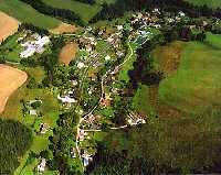 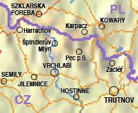
 Bolkov, Arnultovice, Javorník, Lázně Fořt, Zip code: 543 72 obecrudnik@volny.cz The community is member of union: Obec v krkonošském podhůří pod masivem Černé hory. Sousedí s horskými obcemi Černý Důl a Janské Lázně, je vzdálen 11 km od Vrchlabí. Původní název obce byl Heřmanovy Sejfy. Sights:Natural sights:Institutions: |