|
Today is:
Saturday 12.07.2025
Weather

©2008 Mediapool
|
Ergis #ID: 44
Roztoky u Jilemnice
Zip code: 512 31
Number of inhabitants: ca. 933
obec@roztoky-u-jilemnice.cz
www.roztoky-u-jilemnice.cz The community is member of union:
The Krkonose Mts. - Union of Municipalities
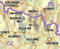
The borough of Roztoky u Jilemnice lies at the foothills of the Krkonose mountains and spreads for 6 km along the roadway from Jilemnice to Stara Paka. The village’s centre of activities and culture is the borough council situated in a building in the centre of the village.
History:
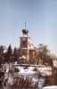
The history of this village goes back to the ancient times of early Christianity when Prklin castle is mentioned in the southern part of the village according to the old legends. An old stone cross is said to date back to that time, and two legends accompany it. The first says that a young noble lady, Zdislava, died here after having fallen from her horse when she had come to the castle to visit her friend. The second says that the stone was put in the place where a young lady fell from a castle window when she was waving good-bye to her departing sister. The stone cross on the Prklin hill top stands even today. The oldest preserved historical records mention the local parish church which had been built in Roztoky before 1360. The church was burnt down, a new church was built later, and in 1739 a new stone church was built in the village.
|
|