©2008 Mediapool
|
hiking path
Ergis #ID: 616
Trail of Czech - Polish Friendship: Spindlerova bouda - Pomezni Boudy
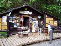
Špindlerův Mlýn Seasonal information centre KRNAP Labský důl - Malá Úpa Hotel POMEZNI BOUDA
detailed map
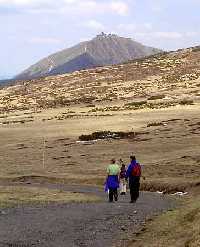
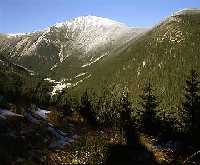
On this route we can see quests both from Alps and Scandinavia as well as something you probably read about in fairy tales - "dead" water - and, of course we will visit the highest and maybe also the most crowded mountain in the Czech Republic.
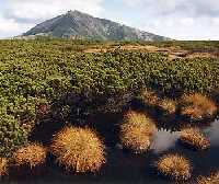
From Dívčí lávky/Girls` footbridges to Špindlerova bouda/chalet and to Malý/Little Šišák. We can reach Špindlerova bouda from Divci lavky following the green-marked trail, then we continue east on the red-marked trail and along the Polish border ascend under the top of Malý Šišák. Slopes are covered with extensive debris, like a sea of rock, and partly covered by dwarf mountain pine. The entire route from Špindlerova bouda to Jelenka chalet under Svorová hora/mountain takes us through the first and most strictly protected zone of the national park. The Krkonoše NP Administration thanks you for following only the marked tourist trails (in winter the trails are replaced by ski routes marked by poles).
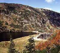
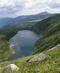
From Malý Šišák to Velký and Malý rybník/Big and Little Pond. The trail of Czech-Polish Friendship leads us along the northern slope. On the right we can see Stříbrný hřbet/Silver ridge (without trees), we pass Polední kámen/Midday Stone, and we can look down at the biggest Krkonoše glacial lake, Velký rybník (Wielki Staw in Polish), with an area of 6,5 ha and a depth of up to 28 m. Another kilometer further, and we will also be above Malý rybník. In winter, besides this route we can also use a shorter trail, marked by poles, from Malý Šišák to Luční bouda.
From Malý rybník to Sněžka. We come to a little mountain road where the red-marked trail is joined by the blue one coming from the left, (i.e. from Polish inland) and they continue together across the Obří pláň/Giant Plain to Slezská bouda (Silesian Chalet) (Obří bouda/Giant Chalet stood on the Czech side). If we don`t descend by the blue-marked trail through Obří důl/Giant Valley (the glacial valley with the biggest Krkonoše corrie) to Pec pod Sněžkou, we can continue by the red-marked trail to the top of Sněžka. (ATTENTION!! The blue-marked trail through Obří důl to Pec pod Sněžkou may be seasonally closed.
From Sněžka to Pomezní boudy/Boundary Chalets. We continue on Obří hřeben/Giant Ridge (in winter, a ski trail, marked by poles, leads us under the ridge on the southern slope). During the descent from Svorová hora/mountain we cross the alpine timberline and dwarf mountain pines are replaced by Norway spruce - at this boundary they grow only 5 to 7 m; they are considerably deformed by the direction of the prevailing winds, and are called flag-trees. From chalet Jelenka, we can reach Pomezní boudy either by the red-marked trail across Soví sedlo or by the yellow-marked trail. From Pomezní boudy we can`t go down any more on sleigh as the tourists in last century did (this popular attraction appeared here in 1817 for the first time in Krkonoše) but public bus can take us to Pec pod Sněžkou or to Trutnov.
Don`t forget to take everything with you brought and on the contrary to leave in the kingdom of Krakonoš everything that belongs here (if you don`t know, Krakonoš, by fairy tale or legend, is the good ghost guarding these mountains for centuries). | Length | 17 km | | Elevation rise | 148 m | | Maximal altitude | 1198 m | | Minimal altitude | 1050 m |
|
|