©2008 Mediapool
|
hiking path
Ergis #ID: 644
Road to the Elbe spring
Vítkovice Parkoviště Horní Mísečky - Vítkovice Parkoviště Horní Mísečky
detailed map
The country along the route gives a great evidence of the rapid evolution of mountain nature as well as of the inhabitants' effort to exploit the mountains for their benefit.
The route begins at the enclave of Horni Misecky. The settlement of this area was first mentioned in the 17th century (1642) and was probably connected with ore mining. Nowadays it is a well known winter sports centre. On the slopes of Medvedin and Krkonos we shall climb up to the height of 1400 m to the Vrbatova chalet. We can choose one of three routes to climb - yellow or red striped marked tourist trails or comfortable Masaryk's Mountain Road. The mountain road was constructed a few years before the World War II as part of the military defence system built on the ridges of the Krkonose Mts. Small concrete bunkers - ropiky - scattered on the ridges of the Krkonose Mts. as well as on the ridges of neighbouring Orlicke, Jizerske and Krusne Mountains remind us of the turbulent history of the first Czechoslovak Republic.
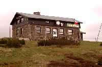
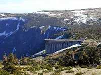
A small stone monument along the road from Vrbatova bouda chalet to Pancava Fall reminds us of the tragedy of Bohumil Hanc - one of the best Czech skiers - and his friend Vaclav Vrbata who both died in a snow-strorm during a competition in 1913. The route towards the Pancava Fall offers us beautiful panorama of the high plateau of Labska and Pancavska meadows with several peat lakes. Unfortunately it also presents a view of the new Labska bouda chalet - a huge giant made of concrete - which was built after the original chalet (built in 1830) burnt down.
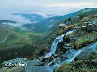
Before we cross Pancava Brook - one of the biggest tributaries of the upper part of the Elbe - the flora changes along the road are worth noticing. Yellow Wood Violet, Bog Violet, Marsh Felwort and the rare Spotted Orchid may be found among tufts of Austrian Deergrass. If we come near the Pancava Brook and are very quiet, we may see trout-like fish Brook trout, which were introduced here at the beginning of this century. They survive even though the water became acid due to acid rains. On the contrary, trouts disappeared from the most of the mountain brooks. Although the Pancava falls 200 meters, the fry of Brook trout survive the plunge to the river below and create a new population in meanders of the Elbe.
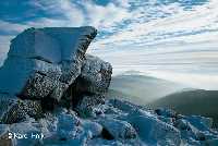
The sheer rocky precipices of Labske jamy corries (Harrachova, Pancavska and Navorska) are a beautiful example of the block decomposition of granite which is the dominant rock here. On the contrary, mica schist and phyllite dominate at the ridge of Krkonos. On your way back, in the area around Zlate navrsi (Cesky hrbet ridge) you will see the block cover remains from the frost weathering of the mountain ridges in the postglacial period. These consist of much smaller and sharper pieces (fragments) when compared to round granite boulders on the slope of Vysoke kolo (Slezsky hrbet ridge). One thing they have in common, though. On surfaces of both we can find varieties of the first pioneers of rock and screes settlement - lichens.
After you walk a little, do not forget to turn to the Ambrozova vyhlidka observation point, a place named after one of the first conservationists in the Krkonose Mts. A panorama of Labske jamy corries and Labsky dul valley opens in front of you. Once upon a time, a glacier up to 70 metres wide shaped deep precipices and rounded valleys. The tongue of the 4 km long glacier gave the Labsky dul valley the typical shape of the letter U. On the other hand, the opposite valley of Bile Labe (White Elbe) in the eastern part of the mountains, has the shape of the letter V. This tells us that valley of Bile Labe was shaped only by the river itself.
On slope of the Pancavska jama corrie there is a place called Schustler's garden with the richest flora on the Czech side of the mountains. It was named after the well-known scholar, Professor Schustler, who proposed that the Krkonose Mts. be claimed a national park in 1923.
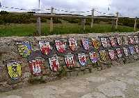
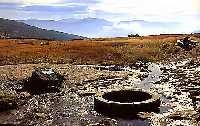
The road up on the edge of the Labske jamy corries can be entered only during summer and autumn. During the winter season it is necessary to use a winter trail marked with posts. The route is safely removed from the cornices and from the sheer slopes of the Labske jamy corries. Both ways will lead you to the Labska bouda chalet. The red stripe-marked tourist trail turns to the north-west there, and after about 1 km you come to the Elbe Spring. It is also possible to use the yellow marked Horse Route direction towards the Polish borders. After you have seen the 300 m deep precipices of the Snezne jamy corries you can walk on the yellow marked trail, climb up the stone outcrop of Violik and again you will get to the Elbe Spring. Part of the symbolic arrangement of the spring is a mosaic of coats-of-arms of towns and cities. These are the towns and cities through which the Elbe flows on its 1200 km long journey towards the North Sea.
There is a rich history tied to the Elbe Spring because it was part of an important commercial salt route, called the Ceska stezka route, which connected Bohemia with Silesia. However, only recently it was settled that the Elbe Spring accurate altitude was 1386,3 m.
There is a yellow stripe-marked trail which goes from the Elbe Spring southward to a junction of trail and then the direction to Harrachov and Horni Rokytnice. Its name - U Ctyr panu (Of four lords) - reminds us fierce property fights between Czech and Silesian aristocrats in the 16th and 17th centuries. There are two ways back to Horni Misecky. You can either walk the little shorter way to Vrbatova bouda chalet, or you can walk on green and yellow stripe-marked trail to the edge of Kotelni jamy corries and then on a red stripe-marked trail along striking tor of Harrachovy kameny rocks and back on Masaryk's Mountain Road to Horni Misecky. The view of a couple of glacial cirques of Kotelni jamy corries, through which th Krakonos's Road leads and view of the Ceska kotlina hollow (weather permitting) complete our travelling through the ridges of the western part of the Krkonose Mts. | Length | 14 km | | Elevation rise | 346 m | | Maximal altitude | 1386 m | | Minimal altitude | 1040 m |
|
|