©2008 Mediapool
|
MTB tour
Ergis #ID: 857
Follow the Lookout Points of Western Krkonose Mountains (MTB)
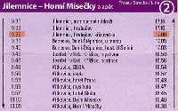
Harrachov Bus-station - Jilemnice Bus-station
detailed map
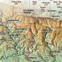
Harrachov – Dvoracky Bouda – Rezek – Roudnice – Jilemnice
Highest point: Dvoracky 1140 m above the sea level
Surface: asphalt roads, forest path, motorway
Characteristic:
Medium difficult MTB-trail in the western part of Krkonose Mts. On this trail, between well-known towns Harrachov and Jilemnice, is many beautiful look-out points to western Krkonose Mts. This trail has little long ascent, however there is one short technically difficult uphill to bouda Dvoracka (15% iclination) on soft ground. That's why this trail is specified as medium difficult.
Description:
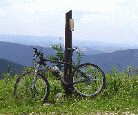
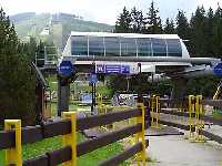
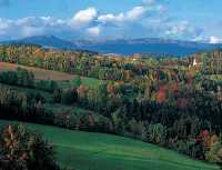
Starting point is in Harrachov, the center of ski jumping in Krkonose Mts. From there follow the road to the lower station of the cableway to Certova hora (1020m above the sea level). From Certova Mtn. and from the path leading to chalet Dvoracky is a great panoramatic view over the western part of Krkonose. From chalet Dvoracky it is a long down hill ride to Jilemnice. The first 500m are technicaly difficult. Strong decline on a soft surface with deep slots is very demanding for the biker and the bike. The one who manages this difficult part continues easily to Rezek and further to Jilemnice.
Options:
This option is cutting out the cableway up to Certova hora. From Harrachov you bike up to Certova hora ( 300 high meters extra). The total discance of the trail will be 6.1 km longer.
See also: Panorama Tour West, medium difficulty
| Length | 28 km | Level | 2 | | Elevation rise | 525 m | Technic | 3 | | Maximal altitude | 1140 m | Landscape | 5 | | Minimal altitude | 464 m | Funfactor | 4 |
|
|