©2008 Mediapool
|
Trekking bike tour
Ergis #ID: 757
Podkrkonose 1 - bellow Krkonose Mountains (Trecking, MTB)
Lánov Information center Lanov - Lánov Information center Lanov
detailed map
Lánov - Kunčice - Jilemnice - Vrchlabí - Lánov (horské a trekové kolo)
Starting point: Information center in Lanov
Surface: asphalt roads, forest trails
Characteristics:
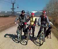
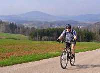
Easy trail for trecking and MTB in the southern part of Krkonose Mts. Around Jilemnice and Vrchlabi there are many look-out points to Krkonose. The trail is going up and down through gentle rolling foothills of the mountains. Ideal trails for families with children, especially in spring when you can still see the snowy covered mountain tops.
Description:
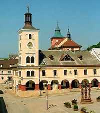
The tour starts in Lanov, in a small village at the foothills of the mountains close to the town Vrchlabi. From the information center bike northeast round an old airport runway of an agricultural company to Kuncice. Continue towards the hill "Predpekli". From here enjoy the great panoramic view over the region. From this point continue biking direction Horni Branna, through a forest to Martinice and Jilemnice. In the center of Jilemnice have a rest at the town square with a water fountain, historical town hall and houses with arches. From Jilemnice head to Horni Branna and around an old castle bike up to the highest point on this tour - hill "Maly Kozinec" (540m above the sea level). The trail will take you to Vrchlabi, where we recommend visiting the town square with a castle, park and many garden restaurants. From Vrchlabi continue to Lanov.
This tour is mostly on the asphalt roads and shortly also on forest pathes and motorways. | Length | 38.6 km | | Elevation rise | 495 m | | Maximal altitude | 530 m | | Minimal altitude | 400 m |
|
|